I have found it difficult to narrow down my research for the CDP so I just wanted to share my starting points and initial ideas with you all in hope of some feedback!
I have started this research by reverting back to my thesis, which was based on how cities (mainly looking at Detroit) have become burdened with derelict building and abandoned spaces. My first conversations with Geraldine on this lead me to look at what makes a city, and how such places can become waste lands. From this I feel I have found that industry is what makes a city or town and is what gives it its identity.
In my thesis I looked at Detroit which was one of the leading cities in the motorcar industry until the industry declined. The city has now been left with hundreds of abandoned factory buildings, houses and areas of complete abandonment. For the CDP I have chosen to base my project in Leicester - a post industrial city itself. The main industries being that of shoe making, hosiery and fabric such as cotton and lace.

Through research I have found that as a result of the decline / relocation of the industries mentioned above, Leicester has a number of abandoned factory buildings and areas of wasteland. Many of these buildings have been previously demolished however, I would propose to regenerate such buildings to give them a use again. I have also seen in my research that the River Soar played a vital role in the transportation of trade goods since the Roman times and although the river is no longer used for this I think it's an interesting point.
I have found two sites which interest me. The first is the Dunisthorpe Mill, the first cotton mill in Leicester which lies on the site of the former Monastery of the Black Friars (which is why the mill is often refferred to as Black Friars Mill). And the second is an area of waste land at the top of Braunstone Gate, located under the old Great Central Railway in the Viaduct. Both sites are along the River Soar and are quite close to one another. The map below shows the location of both sites, the first being north of the second.

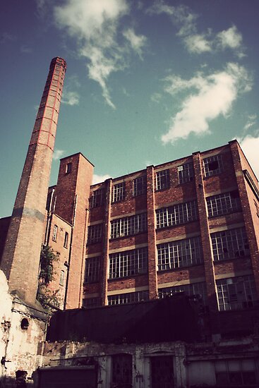
Also, these images are of the Dunisthorpe Mill....


And these images are of the second potential site...


I am unsure on building program at this stage. I am thinking along the lines of art studios / gallery spaces etc.
Any feedback and comments on this is most welcome!
Thanks and see you all at the beginning of term!
Veena :)
Hi Veena,
ReplyDeleteI'm sure you are probably now aware, but I believe Donisthorpe Mill is now undergoing re-development, just started this week I think. Its been designed by a really good practice called 'Levitate', you should be able to see the project below from their website:
http://www.levitate.uk.com/library/friarsmill.php#1
Not certain if this is exactly what is going to be built, but some planning application search will help find out the details.
I've looked into this because my site is not too far away further north directly off the River Soar (about 600metres from the Mills), although I assume you may now go with your second option, which is a little further south isn't it?
Sam, I wondered if you see our projects being in a similar location, as being an issue in any way?
Kind regards,
Dipun
Hi Veena,
ReplyDeleteAre you still working on this project?